Saturday, April 6, 2013
Geocoding
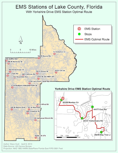
This week our task was to create a map that included a list of geocoded Emergency Medical Station (EMS) locations and to combine that map with an inset that included an optimal route from one of these stations to various neighborhood points.
I enjoyed this lab and it seems like we're really starting to get into the powerful features available in ArcGIS. In my map above, the larger county (Lake County, FL) map shows just the station locations. I turned off the streets for much of the exercise as they really slowed down redrawing. In the end, I preferred the clean look without the streets, but the lab said to include them. I've tried to mute them and make the station labels stand out with a halo. Unfortunately, if I made the label font bigger than 9pt, some station labels started to disappear (turned off due to collision, I guess). I also looked to see if the roads were classified so that I could just show major roads, but the dataset we had to work with didn't differentiate between them.
I got to throw in a little Python programming in the inset map. The labels for the stop addresses have the street address (i.e., 123 Maple Street) concatenated with the zipcode for some reason. The label ends up looking like this: 123 Maple Street, 12345, which isn't too nice. By right-clicking on the Route Stops / Properties, I selected the Labels tab. Clicking on the Text String / Expressions button, I could enter this code:
def FindLabel ( [Name] ):
mylist = [Name].split(',')
return mylist[0]
... which basically splits the field label at the comma and then just returns the first element (just the Street). This made much more usable Stop labels.
Labels:
GIS4043
Subscribe to:
Post Comments (Atom)

No comments:
Post a Comment